Products
 In December of 2017, the first of the new GOES-R Series of satellites “GOES-16” became the operational East satellite after its launch the previous year. GOES-17 was
then launched on March 1, 2018 as the follow-up to obtain GOES-15’s west position. The HRIT/EMWIN service on the Geostationary Operational Environmental R-series
Satellites (GOES-R) has undergone several product transitions over the period from December 2017 through January 2019. The deactivation of the GOES-15 LRIT broadcast,
all three GOES N-P series satellites (GOES-13, GOES-14 and GOES-15) LRIT transponders are inactive, but can be activated in the need of contingency. To find out more
information regarding GOES T and U future launches and status, please visit the GOES-R Launch and Orbit page located on the GOES-R website.
NESDIS provides “GOES Flyout Charts”. The fly-out charts provides information regarding each GOES mission
life and expectancy for operations.
In December of 2017, the first of the new GOES-R Series of satellites “GOES-16” became the operational East satellite after its launch the previous year. GOES-17 was
then launched on March 1, 2018 as the follow-up to obtain GOES-15’s west position. The HRIT/EMWIN service on the Geostationary Operational Environmental R-series
Satellites (GOES-R) has undergone several product transitions over the period from December 2017 through January 2019. The deactivation of the GOES-15 LRIT broadcast,
all three GOES N-P series satellites (GOES-13, GOES-14 and GOES-15) LRIT transponders are inactive, but can be activated in the need of contingency. To find out more
information regarding GOES T and U future launches and status, please visit the GOES-R Launch and Orbit page located on the GOES-R website.
NESDIS provides “GOES Flyout Charts”. The fly-out charts provides information regarding each GOES mission
life and expectancy for operations.
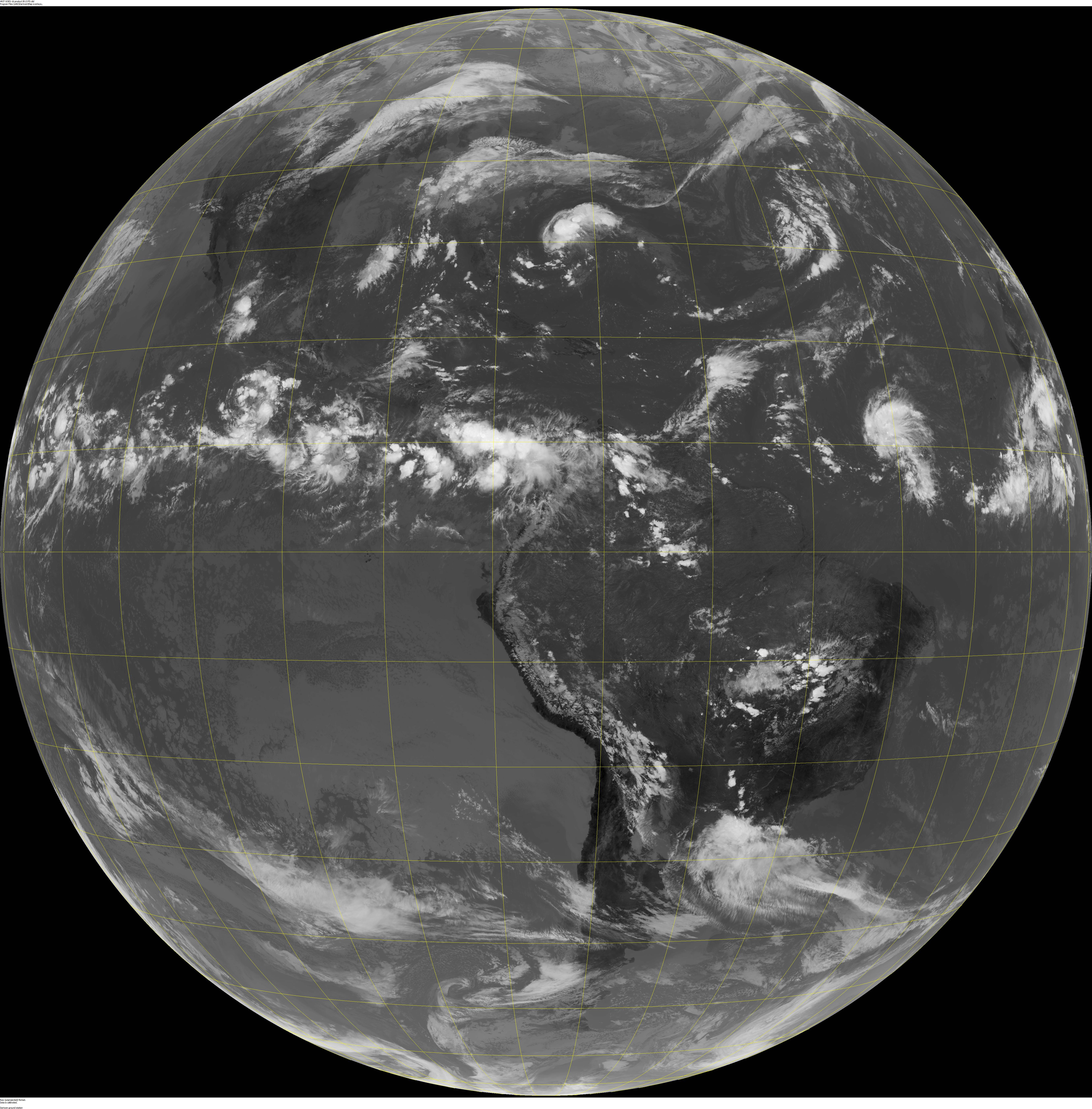 While GOES-13/14/15 carried the GOES Imager having 5 bands of imagery, GOES-R Series carries the Advanced Baseline Imagery (ABI) which has 16 imagery bands. The baseline
spatial resolution varies from 0.5 Km in the visible Band 2 to visible Band 1, near-IR Band 3 and near-IR Band 4 at 1 Km with the remaining bands having spatial resolution
at 2 Km. For more information see GOES-R “Cloud and Moisture Imagery Fact Sheet” or the GOES-R “ABI Bands Quick
Information Guides. This is a significant increase in quality and in quantity of imagery. Of the 16 ABI bands, 7 bands in the full disk sector have been selected for broadcast on HRIT/EMWIN.
HRIT also includes 3 bands in the mesoscale sector. Details of the imagery can be seen in the NOAA GOES-East / GOES-16 HRIT/EMWIN Content Table.
While GOES-13/14/15 carried the GOES Imager having 5 bands of imagery, GOES-R Series carries the Advanced Baseline Imagery (ABI) which has 16 imagery bands. The baseline
spatial resolution varies from 0.5 Km in the visible Band 2 to visible Band 1, near-IR Band 3 and near-IR Band 4 at 1 Km with the remaining bands having spatial resolution
at 2 Km. For more information see GOES-R “Cloud and Moisture Imagery Fact Sheet” or the GOES-R “ABI Bands Quick
Information Guides. This is a significant increase in quality and in quantity of imagery. Of the 16 ABI bands, 7 bands in the full disk sector have been selected for broadcast on HRIT/EMWIN.
HRIT also includes 3 bands in the mesoscale sector. Details of the imagery can be seen in the NOAA GOES-East / GOES-16 HRIT/EMWIN Content Table.
 HRIT/EMWIN also went through a transition with the National Weather Service’s (NWS) Emergency Manager’s Weather Information Network or EMWIN broadcast. Like LRIT, EMWIN
had its own transponder and broadcast on GOES-13/14/15 with a center frequency of 1692.7 MHz. The satellite broadcast of EMWIN is now one component of HRIT/EMWIN. The
EMWIN virtual channels 20-22 carry a large array of NWS produced warnings, watches, forecasts, discussions and graphic imagery products. Also included are other emergency
information; for example, amber alerts. The EMWIN products are now sent as individual messages where on the legacy LRIT broadcast, they were sent as a serial stream in
QBT “block” format. The serial stream on GOES-15 will end when the new NWS Integrated Dissemination Project becomes operational in May of 2019 with the deactivation of the
legacy 1692.7 MHz EMWIN broadcast during the same time-frame. Commercial software packages are available to present the EMWIN information on a CRT as a series of windows.
HRIT/EMWIN also went through a transition with the National Weather Service’s (NWS) Emergency Manager’s Weather Information Network or EMWIN broadcast. Like LRIT, EMWIN
had its own transponder and broadcast on GOES-13/14/15 with a center frequency of 1692.7 MHz. The satellite broadcast of EMWIN is now one component of HRIT/EMWIN. The
EMWIN virtual channels 20-22 carry a large array of NWS produced warnings, watches, forecasts, discussions and graphic imagery products. Also included are other emergency
information; for example, amber alerts. The EMWIN products are now sent as individual messages where on the legacy LRIT broadcast, they were sent as a serial stream in
QBT “block” format. The serial stream on GOES-15 will end when the new NWS Integrated Dissemination Project becomes operational in May of 2019 with the deactivation of the
legacy 1692.7 MHz EMWIN broadcast during the same time-frame. Commercial software packages are available to present the EMWIN information on a CRT as a series of windows.
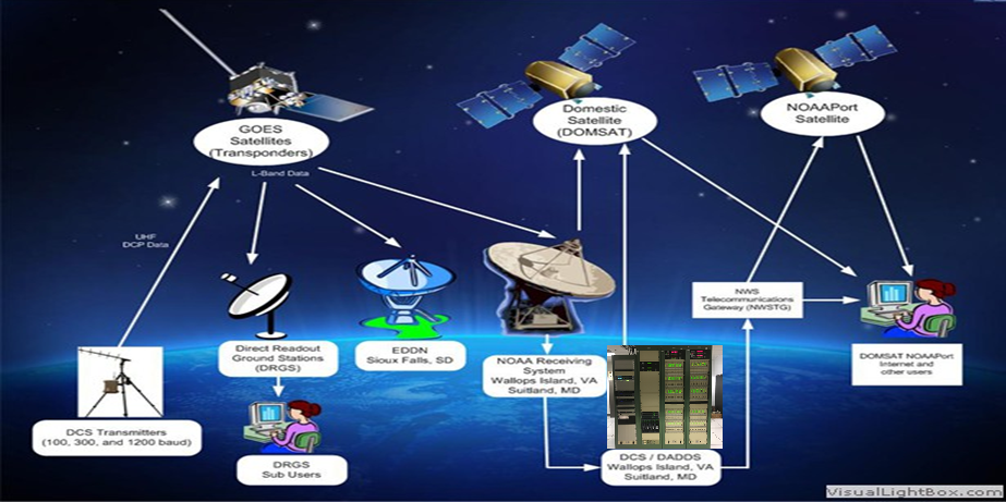 The GOES Data Collection System (DCS) information is a data relay system used to transmit observations from surface based environmental platforms through NOAA's
geostationary satellites, for delivery back to the platform owner. Government agencies (U.S. federal, state, local, and international) anywhere in the footprint of GOES of
which users can apply to utilize the system. Users are given frequency and time slots for their transmissions. The GOES DCS is the critical communication tool for near
real-time observations for almost every network in Continental US and neighboring countries. There are thousands of Data Collection Platforms that transfer their
observations through GOES satellites. Some examples are automatic weather stations, tide and tsunami buoys, river and flood gauges and seismic gauges. There are several
ways to access or receive GOES DCS data. One way is through HRIT/EMWIN with alternative of DOMSAT. GOES DCS observations, while in text, are coded and requires each DCS
user of HRIT/EMWIN to have the proper application to store these files in a database and to decode them if necessary. Each owner of a Data Collection Platforms (DCP) is
the owner of the observation from those platforms.
The GOES Data Collection System (DCS) information is a data relay system used to transmit observations from surface based environmental platforms through NOAA's
geostationary satellites, for delivery back to the platform owner. Government agencies (U.S. federal, state, local, and international) anywhere in the footprint of GOES of
which users can apply to utilize the system. Users are given frequency and time slots for their transmissions. The GOES DCS is the critical communication tool for near
real-time observations for almost every network in Continental US and neighboring countries. There are thousands of Data Collection Platforms that transfer their
observations through GOES satellites. Some examples are automatic weather stations, tide and tsunami buoys, river and flood gauges and seismic gauges. There are several
ways to access or receive GOES DCS data. One way is through HRIT/EMWIN with alternative of DOMSAT. GOES DCS observations, while in text, are coded and requires each DCS
user of HRIT/EMWIN to have the proper application to store these files in a database and to decode them if necessary. Each owner of a Data Collection Platforms (DCP) is
the owner of the observation from those platforms.
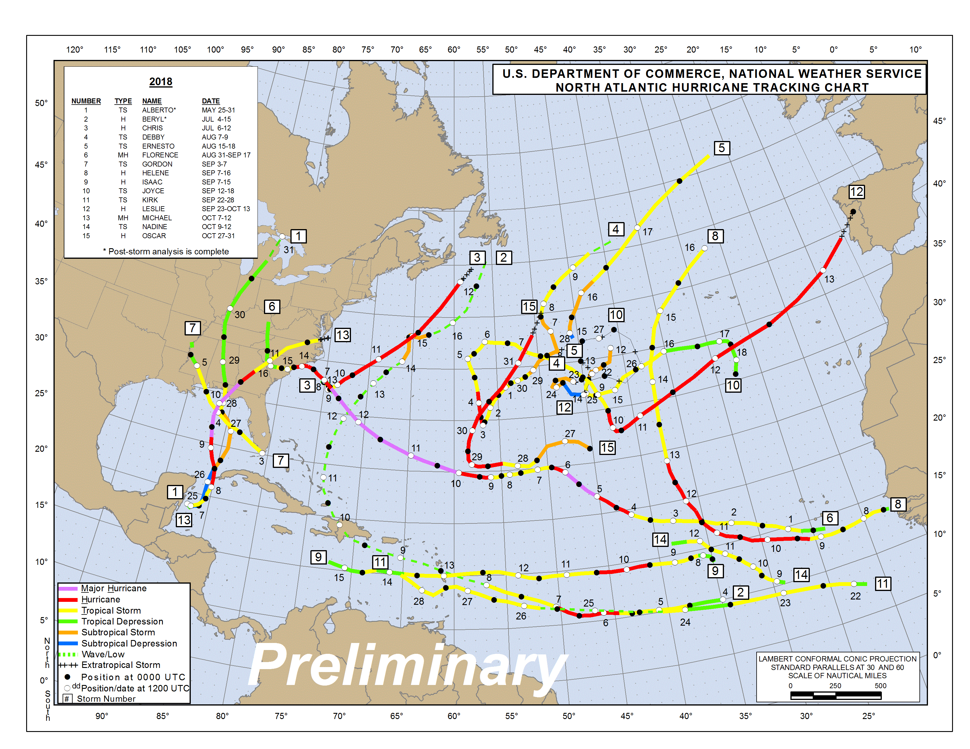 Another product component is a selection of tropical weather and ocean graphics that are pulled from the NWS National Hurricane Center. These include tropical storm
tracks, maritime forecasts, maritime surface charts and discussions along with winds and seas warnings.
Another product component is a selection of tropical weather and ocean graphics that are pulled from the NWS National Hurricane Center. These include tropical storm
tracks, maritime forecasts, maritime surface charts and discussions along with winds and seas warnings.
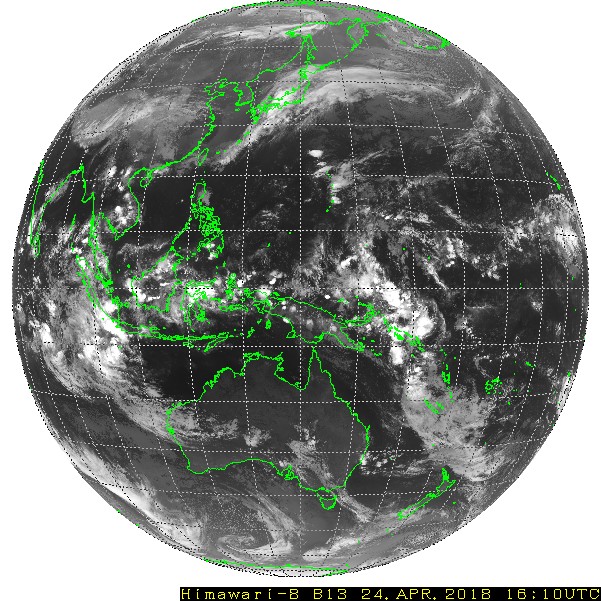 Also included in the HRIT/EMWIN broadcasts are graphic versions of Japan Meteorological Agency (JMA) Himawari and EUMETSAT Meteosat Second Generation Seviri data.
NOAA receives Himawari visible, Infrared and Water Vapor images from the Japanese Meteorological Agency and converts them to NOAA HRIT format. Both imagery datasets
are transmitted each hour over the broadcasts. Himawari carries the HBI or Himawari Baseline Imager instrument which is very similar to the GOES-R ABI. Thus, the full
disk images are nearly compatible with the ABI images that are closest in wavelength and in the case of GOES-West, offer a view of the Pacific area from Asia to much
of North America.
Also included in the HRIT/EMWIN broadcasts are graphic versions of Japan Meteorological Agency (JMA) Himawari and EUMETSAT Meteosat Second Generation Seviri data.
NOAA receives Himawari visible, Infrared and Water Vapor images from the Japanese Meteorological Agency and converts them to NOAA HRIT format. Both imagery datasets
are transmitted each hour over the broadcasts. Himawari carries the HBI or Himawari Baseline Imager instrument which is very similar to the GOES-R ABI. Thus, the full
disk images are nearly compatible with the ABI images that are closest in wavelength and in the case of GOES-West, offer a view of the Pacific area from Asia to much
of North America.
| Product Name |
Format |
Source |
Schedule |
GOES East /
GOES-16/17 (ABI)
Full Disk
Spatial Res: 2 Km
|
HRIT Imagery:
Band 2 Visible
|
PDA /
HRIT/EMWIN
System from ABI |
GOES Schedule
Full Disk
Every 30 Minutes
|
GOES East /
GOES-16/17 (ABI)
Full Disk
Spatial Res: 2 Km
|
HRIT Imagery:
Band 7 Infrared (SW IR)*
Band 8 Infrared (IR/WV)
Band 9 Infrared (IR/WV)
|
PDA /
HRIT/EMWIN
System from ABI |
GOES Schedule
Full Disk
Every 30 Minutes
|
GOES East /
GOES-16/17 (ABI)
Full Disk
Spatial Res: 2 Km
|
HRIT Imagery:
Band 13 Infrared (LW IR)
Band 14 Infrared (LW IR)
Band 15 Infrared (LW IR)
|
PDA /
HRIT/EMWIN
System from ABI |
GOES Schedule
Full Disk
Every 30 Minutes
|
GOES East /
GOES-16/17 (ABI)
Full Disk
Spatial Res: 2 Km
|
HRIT Imagery:
Band 2 Visible
Band 7 Infrared (IR/VW)
Band 13 Infrared (IR)
|
PDA /
HRIT/EMWIN
System from ABI |
GOES Schedule
Full Disk
Every 15 Minutes
|
GOES West /
GOES-15 (GVAR)
Full Disk
Spatial Res: 4 Km
|
LRIT Imagery:
1. Infrared
|
LRIT System
from GVAR |
GOES Schedule
Full Disk
Every 3 hours
|
GOES West /
GOES-15 (GVAR)
North/South
Hemisphere
Spatial Res: 4 Km
|
LRIT Imagery:
1. Infrared
2. Water Vapor
|
LRIT System
from GVAR |
GOES Schedule
North Hemisphere
Every 1 Hour
|
Tropical Storm
Products |
Graphics |
NOAA/NWS
National Hurricane
Center |
Hourly |
Emergency Manager’s
Weather Information
Network (EMWIN) |
Text and Graphics |
NOAA/NWS
EMWIN Program |
As Received |
GOES Data
Collection System
(DCS) |
Text(Coded) |
NOAA /
NESDIS/
OSPO/
SPSD DCS
Program |
As Received |
| Meteosat (MSG –Severi) |
Graphic |
NOAA/
NESDIS/
OSPO SPSD |
Hourly |
| Himawari (HBI) |
Graphic |
NOAA/
NESDIS/
OSPO /SPSD |
Hourly |
Administrative
Text Message
(N/A – Manually
entered in response
to events) |
Text |
LRIT System
Administrators |
Hourly or
As Needed |
| Himawari (HBI) |
Imagery:
1. Visible
2. Infrared.
3. Water Vapor
|
Japan
Meteorological
Agency and
NOAA/
NESDIS/ OSPO
|
Hourly |
*Note: Band 7 is Infrared (IR) with reflected daytime component
*Note: GOES-15 Imagery only available until GVAR deactivation ~May 2019
*Table 2.1: NOAA GOES-East / GOES-16 & 17 HRIT/EMWIN Content Table (Updated 03/01/2018)*
Also, note that the native format of the imagery from the GOES-R Series of satellites is the Network Common Data Form – Version 4, or netCDF4. This format
is transposed into the HRIT/LRIT format for inclusion into the HRIT/EMWIN broadcast and a can be explanation found on
netCDF and
netCDF4 as well as on The
“Coordination Group for Meteorological
Satellites LRIT/HRIT Global Specification”.
On HRIT/EMWIN, the products are arranged into Product Groups and then virtual sub-channels. The HRIT/EMWIN Virtual Channel Identification (VCID) table 2.2 on this page and repeated under the Reception Tab provides a mapping of the products to the Virtual Channel IDs with the product delivery periodicity, satellite availability and format. There is also a link to the home web page of the product. More information on the HRIT/EMWIN broadcast and broadcast reception can be found under their tabs on this site.
| VCID # |
Product Name |
GOES-16
Availability |
GOES-17
Availability |
Period-Min(s) |
Format |
Resolution |
| 0 |
Admin Text |
X |
X |
60 |
Text Messages |
N/A |
| 1 |
Mesoscale Imagery |
X |
X |
15 |
HRIT/LRIT |
0.5km Band
2, 2km for bands
7 and 13 |
| 2 |
CMI Band 2 |
X |
X |
30 |
HRIT/LRIT |
2 km |
| 7 |
CMI Band 7 |
X |
X |
30 |
HRIT/LRIT |
2 km |
| 8 |
CMI Band 8 |
X |
X |
30 |
HRIT/LRIT |
2 km |
| 9 |
CMI Band 9 |
X |
X |
30 |
HRIT/LRIT |
2 km |
| 13 |
CMI Band 13 |
X |
X |
30 |
HRIT/LRIT |
2 km |
| 14 |
CMI Band 14 |
X |
X |
30 |
HRIT/LRIT |
2 km |
| 15 |
CMI Band 15 |
X |
X |
30 |
HRIT/LRIT |
2 km |
| 16 |
G16 CMI Band 13 |
|
X |
180 |
HRIT/LRIT |
2 km |
| 17 |
G17 CMI Band 13 |
X |
|
180 |
HRIT/LRIT |
2 km |
| 20 |
EMWIN - Priority |
X |
X |
Variable |
Text |
N/A |
| 21 |
EMWIN - Graphics |
X |
X |
Variable |
Graphic
(e.g. GIF, JPEG) |
N/A |
| 22 |
EMWIN - Other |
X |
X |
Variable |
Text and Graphic |
N/A |
| 24 |
NHC Maritime
Graphics
Products |
X |
X |
60 |
Graphic
(e.g. GIF, JPEG) |
N/A |
| 25 |
GOES-R/S Level II
Products |
|
|
60-240 |
HRIT/LRIT |
2-10 km |
| 30 |
DCS Admin |
X |
X |
Continuous |
Text |
N/A |
| 32 |
DCS Data
New Format |
X |
X |
Continuous |
Formated Text |
N/A |
| 60 |
Himawari-8 |
|
X |
60 |
LRIT |
4 km |
*Table 2.2: HRIT/EMWIN Virtual Channel Identification (VCID) – Product Table (Updated 03/01/2018)*