GOES Rebroadcast (GRB)
The GOES-R Series satellite’s scientific instruments sense the environment and distribute data to the onboard computer for processing and distribution to the X-Band
antenna for transmission to Earth as a digital data stream. The ground system software at Wallops Command and Data Acquisition Station (WCDAS) processes the Level 0
data and creates Level 1b products. For example, the measurements from the ABI are converted to units of radiance and calibrated, navigated, and remapped to a fixed
grid. The antenna at WCDAS transmits the products to the GOES-R Series satellite for relay through the satellite’s GOES Rebroadcast (GRB) transponder and L-Band antenna
to GRB receive stations, including GRB receive stations at the NOAA Satellite Operations Facility (NSOF).
The GRB provides the primary GOES-16 and GOES-17 relay of full resolution, calibrated, near-real-time direct broadcast Level 1b data from each instrument and Level 2
data from the Geostationary Lightning Mapper (GLM). The GRB is a significant increase in capability from the GOES VARiable (GVAR) service on GOES 13, 14, and 15. The
GRB contains the ABI, GLM, space environment, and solar data that drive the data flow in the NOAA space and Earth environment research and operational frameworks.
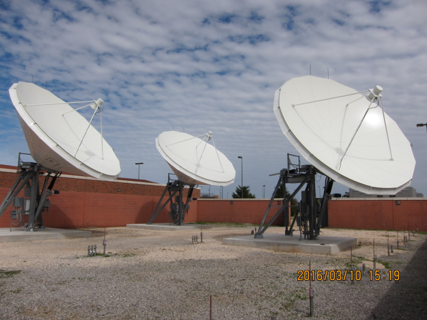
To receive the GRB signal, a user installs a receive station consisting of an antenna, Low Noise Amplifiers, RF/Intermediate Frequency (IF) downconverter, Digital
Video Broadcasting-S2 (DVB-S2) capable receiver and GRB-compatible demodulator, and processing software. The GRB link data rate is 31 Mbps and between 1.5 TB and 2 TB
of data are transmitted during a 24-hour period.
The GRB data stream includes the ABI Level 1b products. In Mode 4, or Continuous full disk mode, the ABI produces a full disk image every 5 minutes. In Mode 3, or Flex
Mode, the ABI produces a full disk every 15 minutes, a CONUS image (resolution 3000 km by 5000 km) every 5 minutes, and two mesoscale domains (resolution 1000 km by 1000
km) every minute or one domain every 30 seconds if it is set to that scanning rate. All 16 Bands are available. A new mode, Mode 6, is being tested and if approved by
NESDIS and NWS then it would provide a full disk image every 10 minutes, CONUS image every five minutes, and images from both mesoscale domains every minute.
GRB to GVAR comparison
|
GOES
Variable
(GVAR) |
GOES
Rebroadcast
(GRB) |
Full
Disk
Image |
Hemispheric
view every
30 minutes |
5 mins (Mode 4),
15 mins (Mode 3),
and 10 mins (Mode 6) |
Other
Modes |
Rapid Scan,
Super Rapid
Scan |
3000 km X 5000 km
(CONUS: 5 minute)
1000 km X 1000 km
(Mesoscale: 30 seconds)
|
| Polarization |
None |
Dual Circular Polarized |
| Polarization |
None |
Dual Circular Polarized |
Receiver
Center Freq |
1685.7 MHz
(L-Band) |
1681.6 MHz
(L-Band) |
| Date Rate |
2.11 Mbps |
31 Mbps |
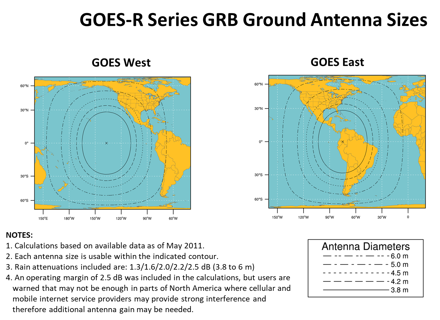
Antenna
Coverage |
Earth Coverage
to 50 |
Earth Coverage
to 5 |
Data
Sources |
Imager
and
Sounder |
ABI (16 bands),
GLM, SEISS,
EXIS, SUVI,
MAG |
Space
Weather |
None |
~2 Mbps |
Lightning
Data |
None |
0.5 Mbps |
 In addition to the NOAA NESDIS GRB receive stations at the WCDAS, NSOF, and CBU, about 70 other sites have
installed or plan to install GRB receive stations.
In addition to the NOAA NESDIS GRB receive stations at the WCDAS, NSOF, and CBU, about 70 other sites have
installed or plan to install GRB receive stations.
The GRB downlink signal from the satellite is at a center frequency of 1686.600 MHz and requires an antenna gain-to-noise-temperature (G/T) of 15.2 dB/K for worst-case
locations. Modulation is either 8PSK with a symbol rate of 7.825768 Million symbols per second (Msps) with a rate 2/3 Forward Error Correction coding or QPSK with a
symbol rate of 8.665938 Million symbols per second (Msps) with a rate 9/10 Forward Error Correction coding. However, the GOES-R program designated QPSK the default
modulation mode in 2017. The nominal antenna size: 4.5-meter dish with a system noise temperature of 120 degrees Kelvin. Off-the-shelf DVB-S2 receivers are available to
receive the IF outputs from the antenna system for each polarization. The DVB-S2 receiver extracts and outputs CCSDS Channel Access Data Units (CADUs) at a rate of 15.5
Megabits per second (Mbps) from each polarization channel. The dual circular polarization facilitates a data rate of 31 Mbps. For more information go to
GRB Downlink Specifications.
 The Product Definition and Users’ Guide (PUG) Volume 4 describes the GRB product content and format and documents the communications and application level protocols
used in the GRB. The PUG Volume 4 lists the products that are on the Left Hand Circular Polarized (LHCP) channel and on the Right Hand Circular Polarized (RHCP). The
ABI Level 1b products on the LHCP channel are similar to the products that were available on legacy GOES Variable (GVAR) DB service provided by GOES-NOP.For more
information go to PUG Volume 4.
The Product Definition and Users’ Guide (PUG) Volume 4 describes the GRB product content and format and documents the communications and application level protocols
used in the GRB. The PUG Volume 4 lists the products that are on the Left Hand Circular Polarized (LHCP) channel and on the Right Hand Circular Polarized (RHCP). The
ABI Level 1b products on the LHCP channel are similar to the products that were available on legacy GOES Variable (GVAR) DB service provided by GOES-NOP.For more
information go to PUG Volume 4.
GRB users can generate products with software purchased from a vendor, developed by the user, or downloaded from the University of Wisconsin – Madison Space Science
and Engineering Center’s (SSEC) Cooperative Institute for Meteorological Satellite Studies (CIMSS). SSEC/CIMSS developed the Community Satellite Processing Package for
Geostationary Data (CSPP Geo) software with funds provided by the GOES-R Program Office.
As of December 2020, NESDIS had accounted for 96 GRB receive stations at 68 sites. GRB is a broadcast so registration is not required. NESDIS requests that users complete a survey on the DCS Administration and Data Distribution System (DADDS) website and join the GRB User Group.
View GRB for more information.
The Rebroadcast (Grb) Downlink Specifications For Users, August 6, 2012, is available at:
https://www.goes-r.gov/users/docs/GRB_downlink.pdf
Also The George C. Marshall Space Flight Center maintains a GOES Health Monitor.