GOES Overview
Geostationary satellites circle the Earth in geosynchronous orbit, which means they orbit the Earth’s equatorial plane at a speed
matching the Earth’s rotation. This allows them to stay in a fixed position in the sky, remaining stationary with respect to a
point on the ground. GOES satellites continually view the Western Hemisphere from approximately 22,300 miles above Earth.
Since 1975, NOAA's Geostationary Operational Environmental Satellites (GOES) have provided continuous imagery and data on atmospheric conditions and solar activity
(space weather). They have even aided in search and rescue of people in distress. GOES data products have led to more accurate and timely weather forecasts and
better understanding of long-term climate conditions. The National Aeronautics and Space Administration (NASA) builds and launches the GOES, and the National Oceanic
and Atmospheric Administration (NOAA) operates them. In October 2015, NOAA celebrated the 40th anniversary of the launch of the first GOES satellite.
GOES satellites are designated with a letter prior to launch and renamed with a number once achieving geostationary orbit. The GOES-N series consists of GOES-13, GOES-14,
and GOES-15.
GOES-N Series Data Book >>>
Information about the Current Status >>>
The Direct Broadcast services on the GOES-N series include the GOES VARiable (GVAR) and the Low-Rate Information Transmission (LRIT). The Direct Broadcast services
on the GOES-R series include the GOES Rebroadcast (GRB) and the High Rate Information Transmission / Emergency Managers Weather Information Network (HRIT/EMWIN).
GOES-16 and GOES-17 (formerly GOES-R and GOES-S)
The GOES-R series is a four-satellite program consisting of GOES-16 and GOES-17 (GOES-R/S) and GOES-T and GOES-U that will
extend the availability of the operational GOES satellite system through 2036. Detailed information is available in the
GOES-R
Series Data Book.
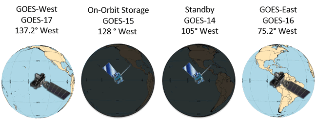
The GOES satellites operate from two primary locations. GOES East at 75.2° W and GOES West at 137.2°W. NOAA also maintains an on-orbit spare GOES satellite in the event
of an anomaly or failure of GOES East or GOES West.
Current Constellation Status
- GOES-15 is currently brought out of on-orbit storage twice per year (February and August) to provide supplemental coverage during peak GOES-17 ABI LHP anomaly periods
- Given recent cooling timeline success, OSPO and NWS are revisiting the need for GOES-15 supplemental operations. Discussion outcome expected in January, 2021
- GOES-T scheduled for launch Dec 5, 2021 and after post-launch checkout will transition to on-orbit storage
The Direct Broadcast services on the GOES-R Series include the GOES Rebroadcast (GRB) and High Rate Information Transmission.
Emergency Managers Weather Information. Network (HRIT/EMWIN).
GRB replaces the GOES VARiable (GVAR) service. Although a GRB receive station costs more than a GVAR receive station, the increase
is capability is significant. GRB provides 31 Mbps vs. GVAR’s data rate of 2.11 Mbps and includes improved products such as ABI and
lightning data from GLM. ABI provides three times more spectral information, four times the spatial resolution, and more than five
times faster temporal coverage than the previous system.
Checkout the GOES Image Viewer. Data and images hosted on the STAR webservers, including the GOES Image Viewer are not official NOAA
operational products, and are provided only as examples for experimental use by remote sensing researchers, experienced meteorologists, or
oceanographers. Although STAR provides "operational" data for some products, the STAR website primarily hosts examples of ongoing experimental product development.
In April 2019, the GOES-16 and GOES-17 Advanced Baseline Imagers started operating in a new 10-minute flex mode (mode 6). Ten-minute flex mode is very similar to the old flex mode (mode 3) with one exception: a full disk image is generated every 10 minutes instead of every 15 minutes. Contiguous U.S. (CONUS) for GOES-16/ Pacific U.S. (PACUS) for GOES-17 scans (3000 km by 50000 km) will still be provided every five minutes, in addition to two mesoscale domains (1000 km by 1000 km) every 60 seconds (or one domain every 30 seconds if scanning the same domain).
There are a number of advantages to 10-minute full disk images. It allows NOAA to match the full-disk scanning cadence of our international partners like the Japan Meteorological Agency (JMA), Korea Meteorological Administration (KMA), and the next generation of European Organisation for the Exploitation of Meteorological Satellites (EUMETSAT) geostationary satellites (starting in 2021). This allows nearly global advanced imager coverage every 10 minutes.
Ten-minute full disk imagery will also be critical to NOAA National Weather Service (NWS) Weather Forecast Offices, National Centers, and the Volcanic Ash Advisory Centers in monitoring hazardous weather conditions and providing additional information in observationally limited areas like over the oceans or in the mountains. The faster temporal cadence will also improve aviation safety. For example, GOES are paramount in monitoring volcanic activity and associated ash plumes. The improved temporal resolution will help monitor these rapidly changing events and help reduce the risk of an airplane encounter with an ash plume. In addition, GOES ABI data can also monitor regions of potential turbulence and since these features can be highly transient, the 10-minute full disk scanning ability will help with monitoring of this hazard.
The timelines, i.e. the number/type of scans in a 10-minute period, are slightly different between GOES-16 and GOES-17. This is intentional as more calibration and navigation scans are included in the GOES-17 mode 6 timeline to mitigate impacts of operating at higher temperatures.”
|
|
|
|
| GOES-A |
GOES-1 |
October 16, 1975 |
Decomissioned 1985 |
| GOES-B |
GOES-2 |
June 16, 1977 |
Decomissioned 1993
Reactivated 1995,
Deactivated 2001 |
| GOES-C |
GOES-3 |
June 16, 1978 |
Decomissioned 2016 |
| GOES-D |
GOES-4 |
September 9, 1980 |
Decomissioned 1988 |
| GOES-E |
GOES-5 |
May 22, 1981 |
Decomissioned 1990 |
| GOES-F |
GOES-6 |
April 28, 1983 |
Decomissioned 1992 |
| GOES-G |
N/A |
May 3, 1986 |
Failed Orbit |
| GOES-H |
GOES-7 |
February 26, 1987 |
Decomissioned 2012 |
| GOES-I |
GOES-8 |
April 13, 1994 |
Decomissioned 2004 |
| GOES-J |
GOES-9 |
May 23, 1995 |
Decomissioned 2007 |
| GOES-K |
GOES-10 |
April 25, 1997 |
Decomissioned 2009 |
| GOES-L |
GOES-11 |
May 3, 2000 |
Decomissioned 2011 |
| GOES-M |
GOES-12 |
July 23, 2001 |
Decomissioned 2013 |
| GOES-N |
GOES-13 |
May 24, 2006 |
On-orbit storage |
| GOES-O |
GOES-14 |
June 27, 2009 |
On-orbit spare |
| GOES-P |
GOES-15 |
March 4, 2010 |
In operation as GOES West |
| GOES-R |
GOES-16 |
November 19, 2016 |
In operation as GOES East |
| GOES-S |
GOES-17 |
March 1, 2018 |
In operation as GOES East |
| GOES-T |
|
|
TBD, Launch readiness date
to be determined in early 2019. |
| GOES-U |
|
|
Launch commitment date 1Q
FY 2025 |
|
GOES
Variable
(GVAR) |
GOES
Rebroadcast
(GRB) |
Full
Disk
Image |
Hemispheric
view every
30 minutes |
5 mins (Mode 4),
15 mins (Mode 3),
and 10 mins (Mode 6) |
Other
Modes |
Rapid Scan,
Super Rapid
Scan |
3000 km X 5000 km
(CONUS: 5 minute)
1000 km X 1000 km
(Mesoscale: 30 seconds)
|
| Polarization |
None |
Dual Circular Polarized |
| Polarization |
None |
Dual Circular Polarized |
Receiver
Center Freq |
1685.7 MHz
(L-Band) |
1681.6 MHz
(L-Band) |
| Date Rate |
2.11 Mbps |
31 Mbps |
Antenna
Coverage |
Earth Coverage
to 50 |
Earth Coverage
to 5 |
Data
Sources |
Imager
and
Sounder |
ABI (16 bands),
GLM, SEISS,
EXIS, SUVI,
MAG |
Space
Weather |
None |
~2 Mbps |
Lightning
Data |
None |
0.5 Mbps |