Reception
The NOAA/NESDIS High Rate Information Transmission / Emergency Managers Weather Information Network (HRIT/EMWIN) broadcast can be received using a VSAT
system with the basic components of a VSAT antenna, low-noise block-down converter (LNB), satellite signal receiver, software to de-encapsulate the
broadcast stream and some type of visualization software. The necessary components and related specifications are located in the accompanying table.
A partial list of component and system manufacturers can be found in the “Satellite Receiving Equipment Manufacturers”. Note that this is a voluntary and partial list of vendors and there are manufacturers not listed and some that may have ceased to participate in the industry.
| Component |
HRIT/EMWIN Broadcast Specifications |
Additional Information |
| Platform |
Operational East and West GOES-R Series Satellites |
- GOES-16 at 75.2 West
- GOES-17 at 137.0 West
- Predicted Launch March 1, 2018
- Predicted Operational West Fall 2018
|
| Broadcast |
Operating Frequency Range |
L-Band |
|
Center Frequency |
1694.1 MHz |
|
Data Rate |
400 Kbps |
|
Symbol Rate |
927 Ksps |
|
Modulation - BPSK |
- Convolutional rate ½ code with constraint length 7 concatenated with Reed Solomon (255,223) with Interleave = 4
- Square Root Raised Cosine filtering using an Alpha factor of 0.3
- The resulting “Necessary Bandwidth” for this signal will be 1.205 MHz
|
|
Polarization - Linear |
Vertical Offset |
| Antenna System |
Antenna System |
- At 5 degree elevation, the minimum antenna is 1.2 meter.
- At 10 degrees or more elevation the minimum size is 1.0 meter
|
Low-Noise
Block-Down |
L-band |
Example:
- Input 1691 MHz
- Output 137.5 Mhz
|
| Satellite Receiver |
L-band |
|
| Software |
N/A |
- De-encapsulates HRIT/LRIT files
|
|
|
- Visualization and Manipulation of Files
- Optional Applications (examples)
- EMWIN visualization application
- GOES-DCS database software
|
*Table 4.1: HRIT/EMWIN Broadcast Reception Components and Specifications (Updated 12/28/2018)*
HRIT/EMWIN can be received over much of the Western Hemisphere between extreme Western Africa and extreme Eastern Australia and Eastern Polynesia. The combination of
the low rain-fad characteristic of the L-band signal and the small aperture antenna required for reception allows for simultaneous reception of GOES-R Series and
Himawari reduced resolution imagery, the EMWIN content and GOES-DCS observations.
On HRIT/EMWIN, the products are arranged into Broadcast Groups and then virtual sub-channels. The HRIT/EMWIN Virtual Channel Identification – Product Table
(table below) on this page and repeated under the Products Tab provides a mapping of the products to the Virtual Channel IDs with the product delivery periodicity and
format.
| VCID # |
Product Name |
GOES-16
Availability |
GOES-17
Availability |
Period-Min(s) |
Format |
Resolution |
| 0 |
Admin Text |
X |
X |
60 |
Text Messages |
N/A |
| 1 |
Mesoscale
Imagery |
X |
X |
15 |
HRIT/LRIT |
0.5km Band
2, 2km for bands
7 and 13 |
| 2 |
CMI Band 2 |
X |
X |
30 |
HRIT/LRIT |
2 km |
| 7 |
CMI Band 7 |
X |
X |
30 |
HRIT/LRIT |
2 km |
| 8 |
CMI Band 8 |
X |
X |
30 |
HRIT/LRIT |
2 km |
| 9 |
CMI Band 9 |
X |
X |
30 |
HRIT/LRIT |
2 km |
| 13 |
CMI Band 13 |
X |
X |
30 |
HRIT/LRIT |
2 km |
| 14 |
CMI Band 14 |
X |
X |
30 |
HRIT/LRIT |
2 km |
| 15 |
CMI Band 15 |
X |
X |
30 |
HRIT/LRIT |
2 km |
| 16 |
G16 CMI Band 13 |
|
X |
180 |
HRIT/LRIT |
2 km |
| 17 |
G17 CMI Band 13 |
X |
|
180 |
HRIT/LRIT |
2 km |
| 20 |
EMWIN - Priority |
X |
X |
Variable |
Text |
N/A |
| 21 |
EMWIN - Graphics |
X |
X |
Variable |
Graphic
(e.g. GIF, JPEG) |
N/A |
| 22 |
EMWIN - Other |
X |
X |
Variable |
Text and Graphic |
N/A |
| 24 |
NHC Maritime
Graphics Products |
X |
X |
60 |
Graphic
(e.g. GIF, JPEG) |
N/A |
| 25 |
GOES-R/S Level II
Products |
|
|
60-240 |
HRIT/LRIT |
2-10 km |
| 30 |
DCS Admin |
X |
X |
Continuous |
Text |
N/A |
| 32 |
DCS Data
New Format |
X |
X |
Continuous |
Formated Text |
N/A |
| 60 |
Himawari-8 |
|
X |
60 |
LRIT |
4 km |
*Figure 4.2: HRIT/EMWIN Virtual Channel Identification – Product Table (Updated 02/20/2018)*
There is also a link to the home web page of the product. More information on the HRIT/EMWIN broadcast and products can be found under their tabs on this site. The broadcast stream is based on the HRIT/LRIT and CCSDS Standards. Depending on the software used to de-encapsulate the broadcast stream, users can select which products to store or archive on their systems.
Most products are in formats that are easily viewed by most computer systems such as text, jpeg and gif. The GOES DCS observations, while in text, are coded. Each owner of a Data Collection Platforms (DCP) is the owner of the observation from those platforms. Each DCS user of HRIT/EMWIN is responsible for having an application to store these files in a database and to decode them.
The native format of the imagery from the GOES-R Series of satellites is the Network Common Data Form – Version 4, or netCDF4. This format is transposed into the HRIT/LRIT format for inclusion into the HRIT/EMWIN broadcast. View the netCDF and netCDF4 for more information. Visit the “Coordination Group for Meteorological Satellites LRIT/HRIT Global Specification”. Most commercial HRIT/EMWIN or XRIT systems contain software that will view and / or manipulate the images in HRIT format.
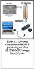 A solution for do-it-yourselfers and hobbyists is documented on the GOES-R website at https://www.goes-r.gov/users/hrit-links.html, it is also available on the “Aerospace prototype” page on the NOAASIS website. This solution uses a “simple software-based radio receiver to process the received radio frequency signal from an antenna and demodulator” and can be combined with a VSAT antenna.
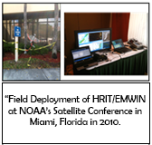 During the NOAA Satellite Conference in Miami, Florida in the spring of 2010, a provisional installation of a HRIT/EMWIN system was installed in the parking lot outside the hotel conference center. The system consisted of a lightweight antenna, LNA, the original version of the prototype receiver and software, a laptop computer, a normal CRT and a batter for power. It successfully showed the satellitbe imagery of an approaching squall line with thunderstorm activity along with the EMWIN warning information and graphics.
NOTIFICATION OF POSSIBLE FREQUENCY INTERFERENCE
The U.S. Government auction of L-band frequency spectrum (1695 to 1710 MHz) adjacent to GOES-R HRIT/EMWIN transponder frequency is likely to adversely impact the reliability of HRIT/EMWIN signal reception in the US due to cell phone interference.
- We cannot accurately quantify the interference or identify when the spectrum will be occupied.
- Preliminary interference analysis will be revisited when the specific service characteristics are better known.
- An Aerospace/GOES-R presentation “Future HRIT/EMWIN Concerns: HRIT/EMWIN Receiver User Equipment RF Compatibility”
- The U.S. Government is investigating options to improve operations in a shared spectrum environment.
- Radio Frequency protection zones granted by the FCC were not offered to non-Federal sites/systems/users.
- Users may employ methods for minimizing interference (e.g., blocking source of interference).
View all of
Geostationary Satellites Status and their instruments>>
View the imaging
“Schedules and Scan Sectors”>>
NOAA/NESDIS/OSPO posts notifications that consist of
“information about NOAA's satellite operations.” To “decode the ".txt" filenames listed above, MSGXXXHHMM.NN.txt, MSG means "Message", XXX is the Julian Date, HHMM is the time of the message and NN is the sequence number.”
Users can also be put on email distribution of the notifications by emailing the NESDIS Help Desk at
ESPC Operations or
visit the Contact Page>>.